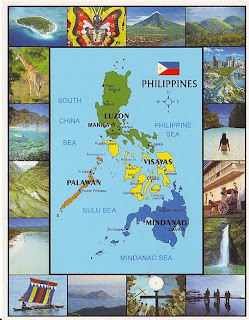
Just a little background about my country, the Philippines (Filipino: Pilipinas) is an archipelago of 7,107 islands located in Southeast Asia. The total land area is almost 300,000 square kilometers. Only approximately 1,000 of its islands are populated, and fewer than one-half of these are larger than 2.5 square kilometers. Luzon and Mindanao, together with the cluster of the Visayan Islands that separate them, represent the three principal regions of the archipelago that are identified by the three stars on the Philippine flag. Topographically, the Philippines is broken up by the sea, which gives it one of the longest coastlines of any nation in the world.
The map shows three shaded island groups of the country: Luzon in green, Visayas in yellow, Mindanao in blue, Palawan in orange is still part of Southern Luzon. The images around the map are (from left topmost moving clockwise): Idyllic Coco-Loco Island in Palawan -- Ati-atihan Festival, Aklan -- Perfectly-coned Mayon Volcano, Legaspi -- Chocolate Hills of Bohol -- Makati, the business district of Manila -- Beautiful lagoon of El Nido, Palawan -- Horse-driven calesa found in Intramuros, Manila -- Pagsanjan Falls in Laguna -- Monument of Leyte Landing of Douglas McArthur -- Magellan's Cross in Cebu, cradle of Philippine Catholic religion -- Taal Volcano and Lake, Tagaytay -- Muslim vinta in Zamboanga -- White Beach of Boracay Island -- Banaue Rice Terraces, North Luzon -- Rich aquatic life of the Philippine Seas -- Wild local and African animals in Calauit Island, Northern Palawan
I actually don't have any information on where they copied the printed map on the postcard, so I don't know if its a reproduction of a painting or something else. The back of the postcard has no information at all! But good thing is that it shows some of the famous landmarks in the country, from the famous Banaue Rice Terraces to Mayon Volcano! I just wish I could find online the original source and at least a little bit information about it.
SOURCE:
Geography of the Philippines WikiPilipinas Entry


2 comments:
Hi, where did you buy the 2nd Map postcard (illustrated map postcard)? Thankyou! :-D
hi zarah, bought it at the national bookstore few years back.. cant find the postcard any more sa mga shelves nila :(
Post a Comment