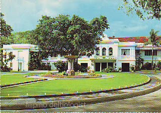
The postcard shows the swimming pool of one of the beach resorts in Bauang, La Union. Unfortunately the postcard does not mention the name of the resort.
26 March, 2009
25 March, 2009
M1022: Traveling Handicraft Store Postcard
The postcard shows a traveling handicraft store. The back of the postcard reads that such stores travel some 150 km to sell their wares, mostly handicrafts like baskets, winnowing baskets, baby hammock, etc.
RELATED ENTRY:
M28: Traveling Vendor Postcard
RELATED ENTRY:
M28: Traveling Vendor Postcard
24 March, 2009
M1015: Rizal Avenue Postcard
The postcard shows a view of Rizal Avenue as seen in the 60s. Seen in the postcard are some of the famous cinemas in the area, Ideal Theater and State Theater (right side of the postcard after Otis), and also the Otis Department Store. Still no Manila LRT Yellow Line!
Prior to and right after World War II, Rizal Avenue was center of the city's social life, with the street lined with shops, restaurants and movie theaters like the Ideal and State Theaters. The Ideal Theater, designed by Pablo Antonio in 1933, was demolished in the 1970s to give way to the construction of a department store. The State Theater, designed by Juan Nakpil, was built in the 1930s with its art deco design. It closed in the 1990s and was demolished in 2001. The main culprit of the deterioration of Rizal Avenue area was the LRT.
Rizal Avenue: The Sta. Cruz district's main street and Manila's longest (from Carriedo in Quiapo to Monumento in Caloocan City) is popularly known as Avenida Rizal named after Jose Rizal. Formerly Calle Dalumbayan, which meant edge of town or end of civilized territory.
SOURCES:
Rizal Avenue Wikipedia Entry
Standalone movie theaters of the Philippines
Daluyan: Historical Dictionary of the Streets of Manila
by National Historical Institute, p. 92
23 March, 2009
M1013: Las Piñas Salt Bed
The postcard shows the salt beds of Las Piñas where salt is produced the old fashioned way. This made the city "Salt Center of Metro Manila." In the 80s, the salt making industry was affected by the construction of the Coastal Road and reclamation project along the Manila Bay.
22 March, 2009
M1012: Malacañang Palace Postcard
This deckle edge postcard (has an uneven or wavy edge) shows the Malacañang Palace and its grounds in Manila, the official residence of the President of the Republic of the Philippines.
RELATED ENTRY:
Malacañang Palace Postcard
RELATED ENTRY:
Malacañang Palace Postcard
Subscribe to:
Comments (Atom)


