The postcard shows a view of Rizal Avenue as seen in the 60s. Seen in the postcard are some of the famous cinemas in the area, Ideal Theater and State Theater (right side of the postcard after Otis), and also the Otis Department Store. Still no Manila LRT Yellow Line!
Prior to and right after World War II, Rizal Avenue was center of the city's social life, with the street lined with shops, restaurants and movie theaters like the Ideal and State Theaters. The Ideal Theater, designed by Pablo Antonio in 1933, was demolished in the 1970s to give way to the construction of a department store. The State Theater, designed by Juan Nakpil, was built in the 1930s with its art deco design. It closed in the 1990s and was demolished in 2001. The main culprit of the deterioration of Rizal Avenue area was the LRT.
Rizal Avenue: The Sta. Cruz district's main street and Manila's longest (from Carriedo in Quiapo to Monumento in Caloocan City) is popularly known as Avenida Rizal named after Jose Rizal. Formerly Calle Dalumbayan, which meant edge of town or end of civilized territory.
SOURCES:
Rizal Avenue Wikipedia Entry
Standalone movie theaters of the Philippines
Daluyan: Historical Dictionary of the Streets of Manila
by National Historical Institute, p. 92
24 March, 2009
23 March, 2009
M1013: Las Piñas Salt Bed
The postcard shows the salt beds of Las Piñas where salt is produced the old fashioned way. This made the city "Salt Center of Metro Manila." In the 80s, the salt making industry was affected by the construction of the Coastal Road and reclamation project along the Manila Bay.
22 March, 2009
M1012: Malacañang Palace Postcard
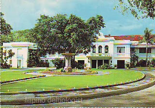
This deckle edge postcard (has an uneven or wavy edge) shows the Malacañang Palace and its grounds in Manila, the official residence of the President of the Republic of the Philippines.
RELATED ENTRY:
Malacañang Palace Postcard
RELATED ENTRY:
Malacañang Palace Postcard
21 March, 2009
M1010: Ruins of Camalig Postcard
The postcard supposedly shows the Ruins of Camalig. The back of this postcard reads:
This is actually the Bantay Church Bell Tower in Bantay, Ilocos Sur. Just like any other Spanish churches in Ilocos, the bell tower is constructed separate from the main church. The bell tower stands a top the nearby Calvario Hill with a blind Gothic arch over its doorway. The belfry was used also as watchtower by towns people to see incoming invaders.
RELATED ENTRY:
Shrine of Nuestra Senora de la Caridad Postcard
SOURCES:
Ilocos Review, Volume 3, Number 1 & 2, January-December 1971. Churches in Ilokandia, p. 280
Province of Ilocos Sur Things To Do
Ruins of Camalig - The bell tower, what was left of the church, after the destructive eruption of the beautiful Mayon on February 11, 1814.
This is actually the Bantay Church Bell Tower in Bantay, Ilocos Sur. Just like any other Spanish churches in Ilocos, the bell tower is constructed separate from the main church. The bell tower stands a top the nearby Calvario Hill with a blind Gothic arch over its doorway. The belfry was used also as watchtower by towns people to see incoming invaders.
RELATED ENTRY:
Shrine of Nuestra Senora de la Caridad Postcard
SOURCES:
Ilocos Review, Volume 3, Number 1 & 2, January-December 1971. Churches in Ilokandia, p. 280
Province of Ilocos Sur Things To Do
20 March, 2009
M1006: Quezon Hall Postcard
The postcard shows the Quezon Hall of the University of the Philippines in Diliman, Quezon City. The hall was named after former president Manuel L. Quezon. It is located behind the Oblation statue as an arch.
Quezon Hall was designed by Juan Felipe Nakpil. Quezon Hall, one of the six pioneer buildings of the Diliman campus, was among the buildings constructed at the Diliman campus in the early 1950s, following the University’s exodus from Padre Faura to Diliman in 1949. An imposing colonial structure at the end of the University Avenue, it was completed in 1950.
RELATED ENTRY:
University of the Philippines, Diliman Postcards
SOURCES:
Legacy of 2 UPD buildings underscoredThings and Places named after Quezon
Subscribe to:
Comments (Atom)


